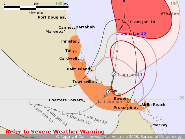
Tropical Low 12U is moving closer to the northeast Queensland coast and is expected to develop into a tropical cyclone later this afternoon. Current forecasts indicate the system will reach category 2 intensity before making a coastal crossing early Sunday morning between Ingham and Bowen.
As of 1:00 pm AEST, the tropical low was located in the Coral Sea between the North Tropical Coast and Flinders Reef. The system is situated within 65 kilometres of 17.1 degrees South and 147.7 degrees East, approximately 260 kilometres north northeast of Townsville and 205 kilometres east of Cairns. It is moving south at 17 kilometres per hour and continues a south-southwest track towards the Queensland coast. Sustained winds near the centre are 95 kilometres per hour, with wind gusts reaching 130 kilometres per hour.
A warning zone has been established from Innisfail to Proserpine, including Townsville, Bowen, Palm Island, and the Whitsunday Islands. While the forecast path indicates the most likely direction and strength, the cyclone centre may take an alternative track within the grey zone, and winds can be expected beyond this area.
Destructive wind gusts of up to 130 kilometres per hour are possible from late tonight and early Sunday morning. These conditions are more likely to affect offshore locations or exposed coastal areas between the south of Townsville and Proserpine. Gales with damaging wind gusts of 100 kilometres per hour are expected to develop over coastal areas between Innisfail and Airlie Beach this afternoon or evening. These gales may extend to Proserpine and adjacent inland areas tonight before easing as the system moves inland on Sunday.
Heavy rainfall that may lead to flash flooding is forecast for the region between Innisfail and Proserpine today. Locally intense rainfall is possible between Tully and Proserpine later today, which could cause dangerous and life-threatening flash flooding. Tides between Innisfail and Proserpine are likely to be higher than normal over the weekend, though they are not expected to exceed the highest tide of the year.
A Severe Weather Warning is currently active for heavy to locally intense rainfall and damaging winds across the northeast and central Queensland coasts. Flood Watches and Warnings also remain in effect. People located between Innisfail and Proserpine, including those in Innisfail, Townsville, Palm Island, Bowen, and Airlie Beach, are advised to take precautions and listen to the next advice at 5 pm.